Kilauea Eruptions and the Hawaiian Archipelago:
The Geology of Plate Tectonics and Hotspots
| Correspondence | Barry Wood, barrywood1940@yahoo.com Citation | Wood, B. (2019) Kilauea Eruptions and the Hawaiian Archipelago: The Geology of Plate Tectonics and Hotspots. Journal of Big History, III(1); 1 - 16. DOI http://dx.doi.org/10.22339/jbh.v3i1.3111 |
Abstract
A four-month surge of Mount Kilauea eruptions (May to August 2018) on the Big Island reminds us that the whole chain of Hawaiian islands has been built by volcanic activity. Kilauea is one of five volcanoes that built the Big Island; a future island (Lo’ihi) is growing on the seafloor 20 miles to the southeast. A plume of rising magma from deep inside the Earth’s mantle underlies a seafloor hotspot; lava is forced through vents in the Earth’s crust; as the Pacific seafloor moves northwest from its origin at the East Pacific Rise, this stationary hotspot creates a line of volcanic islands. To the northwest, submerged seamounts remain as remnants of former islands once formed over this hotspot. A northward chain known as the Emperor Seamounts reveals that this same hotspot has created more than 100 volcanoes over 70 million years. The Hawaiian and Emperor seamounts are not unique. The New England Seamounts off the coast of Massachusetts and similar chains in the South Atlantic record the east-west spread of the Atlantic seafloor over mid-ocean hotspots. In the Indian Ocean, north-running seamount chains record the northward movement of the Indian plate following the breakup of Pangea. In the United States, a line of extinct craters west of Yellowstone across Idaho mark the westward movement of the North American plate over the hotspot now under Yellowstone National Park.*
A dramatic upsurge of volcanic activity on the Big Island of Hawaii on May 3, 2018, was reported worldwide, generally as isolated news items: a new fissure, an explosive fireworks display, lava flowing into the sea, Almost daily we saw images and photos of geological change, a visible process photographed, and shown on the TV news (Figure 1).
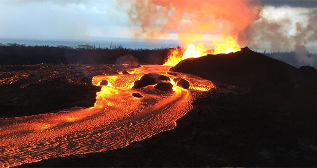 |
| Figure 1. Kilauea Lava Flow. Mount Kilauea on the Big Island of Hawaii has been in quiet eruption since 1983 with limited impact on island residents. Since 3 May 2018, a dramatic upsurge of volcanic activity has affected neighborhoods and residents, forcing evacuations and sending lava flows toward the eastern coast. Photo: NPR. |
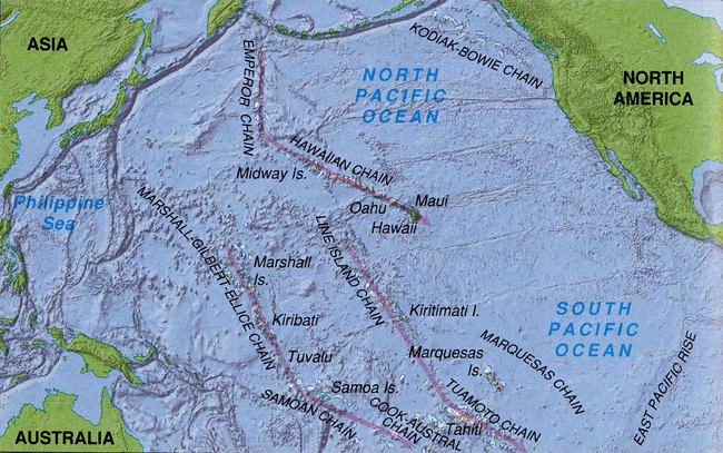
Rarely did we find the Kilauea eruptions placed in the larger contexts of island building, mantle plumes, plate tectonics, the evolution of islands into atolls, and the astonishing line of northwest-running seamounts with their abrupt northward turn, now evident in the line of Emperor Seamounts running all the way to the Aleutians 3,600 miles away (See Figure 5).
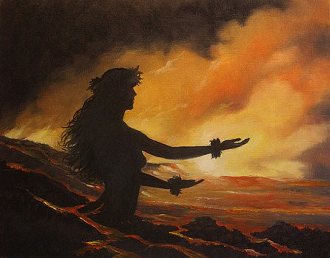
Hawaiians are intensely aware of the drama of earthquakes, eruptions, and lava flows, vividly narrated in their centuries-old stories of Pele (Beckwith 1982), goddess of Hawaii’s volcanoes (Figure 2).
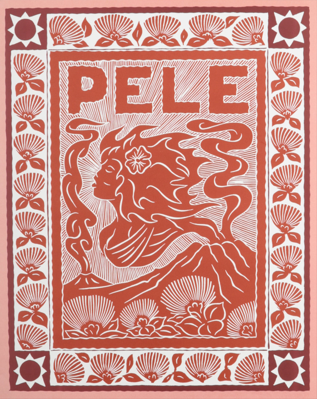 |
| Figure 2. Dietrich Varez is one of several artists who have created images of Hawaiian myth associated with ever-present volcanic activity. Here the cover of Pele: The Fire Goddess (1991) illustrates his innovative print-paintings that accompany the story of Pele by Pua Kanaka’ole Kanahele published by the Bishop Museum Press, Honolulu. |
In Hawaii, the past is resident in the present, not only in the continuing drift of the archipelago across the Pacific but also in island-building itself, including a new undersea volcano a few miles away destined to become another island in the Hawaiian chain. Big Island eruptions provide a contemporary view of geological change within the Earth chapter of the Big History narrative. Ancient mythic stories often suggest physical events we describe in scientific terms: artistically Pele’s emotions of love and devotion punctuated by sudden episodes of betrayal and revenge metaphorically reenact geological periods of volcanic quietude and eruptive violence. As Big History teachers in search of vivid illustrations of geological change at work, it behooves us to take advantage of these events to articulate one of the central chapters in this epic of the Earth—one of the few Big History stories that can be brought to life in present time.
More than a century ago, the geologist James Dana visited the eight major islands of the Hawaiian Archipelago. He observed a distinct difference in their ages: the islands at the northwest end, Kaua’i and Ni’ihau, were the oldest; the others were progressively younger with the Big Island at the southeast end the youngest. In Characteristics of Volcanoes, with Contributions of Facts and Principles from the Hawaiian Islands (1891) Dana pointed out that as we move northwest along the island chain we find that erosion is progressively more advanced, a certain sign of increasing age. Dana was unable to provide an explanation and none was forthcoming for the next sixty years. The theory of continental drift put forth by Alfred Wegener in The Origin of Continents and Oceans (1915) focused primarily on the continents; presumably islands were unassimilated fragments. Moreover, Wegener’s theory impressed few geologists for lack of any explanation for how huge land masses could possibly move. But observations collected during the International Geophysical Year (IGY), July 1957 to December 1958, led to a radical new geological perspective. Oceanographer Robert Dietz (1961), who worked with the Geodetic Survey during the IGY, published a theory of ocean basin evolution and sea floor spreading. His research colleague, geologist Harry Hess, who had served in the U.S. navy, wasconcerned with possible seafloor obstacles that might interfere with deep submarine movement; his paper, “The History of Ocean Basins” (1962), identified mid- ocean ranges and added theoretical foundations for seafloor spreading.
From this cluster of publications, the theory of plate tectonics was born, and geologists began examining every part of the planet, including the Hawaiian Archipelago. Canadian geologist John Tuzo Wilson (1963a, 1963b) suggested that the crustal plate underlying the Pacific Ocean might be moving over a stationary source of upwelling lava that he called a “streaming point”: thus, “each streaming point givesrise to a succession of volcanoes.”Chris Christofferson is credited for coining the term “hotspot” for Wilson’s streaming point to which Princeton geologist W. Jason Morgan (1971, 1972) added a theory of thermal plumes from deep within the Earth’s mantle as an explanation for hotspots. In a single decade, a master theory of geological change was in place, providing a foundation for understanding mountain building, earthquake activity around the world, and concentrations of volcanic activity along plate margins. For our purposes, the recognition of plate movement and stationary hotspots provided an explanation for the creation of the Hawaiian Islands and, it turns out, other island and seamount chains around the world.
This may be the appropriate place to frame a justification for this essay. In surveying precursors to Big History—Preston Cloud’s Cosmos, Earth, and Man (1978), Nigel Calder’s Timescale (1983), Brian Swimme’s and Thomas Berry’s Universe Story (1988)—we note that Hawaii receives no attention. In subsequent Big History books—The Structure of Big History (Spier 1996), Maps of Time (Christian 2004), Big History from the Big Bang to the Present (2007), Big History: Between Nothing and Everything (Christian et al 2014), A Most Improbable Journey (Alvarez 2017), and Origin Story (Christian 2018)—mention of Hawaii is limited to migrants who populated it a few centuries ago from islands to the south. Its sole treatment to date in the context of Big History occurs within a more extended survey of tectonic plates, hot spots, and plumes by Garcia-Moreno et al (2017).
This 70-million-year narrative amounts to one of the most dramatic chapters in the Earth segment of the Grand Narrative. If we begin with the Big Island where rivers of lava have spread across hundreds of acres over the past few weeks, we see in miniature how the Big Island was built. Red hot lava pouring into the ocean provides a view of island building that has been going on for a million years (Figure 3).
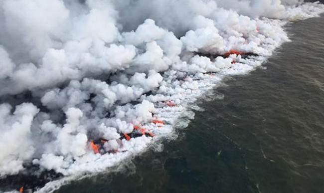 |
| Figure 3. Lava fountains from Kilauea’s fissures flow toward the ocean, altering and extending the coastline. Lava reaching the coast leads to an explosive encounter—a battle of fire and water. Since May 2018 hundreds of acres have been added to the east coast of the Big Island. Photo: USGS. |
The building of the Big Island began 600 thousand years ago with Manukona, the first of six volcanoes, which erupted for approximately 300 thousand years until plate movement led to the emergence of another volcano, Kohala, miles to the east that eventually conjoined with Manukona. This continued with subsequent volcanoes—Maunja Kea, Mauna Loa, Huadlalai, and finally Kilauea, each subsuming the earlier ones, each higher than the last, with Kilauea now towering 13,792 feet above sea level.
The result is a composite island of more than 4,000 square miles averaging 64 miles in diameter. The exposed third conceals a vast undersea bulk of 20,000 feet elevation; topped by the island elevation, this adds up to a mountain 32,000 feet high, 3,000 higher than Mount Everest. Its shallow undersea slopes spread out to a seafloor foundation of well over 30,000 square miles. The volcanic material sufficient to build an island of such bulk challenges imagination suggesting that continuous eruption over millennia has been the rule rather than exception.
The migration of this enormous mass is part of a much larger story. The Hawaiian islands are migrating to the northwest, carried on seafloor that originated at the East Pacific Rise far to the southeast where upwelling lava pushes into the north-south boundary between two crustal slabs, slowly wedging these massive tectonic plates apart. As it rises and spreads, lava creates new seafloor. Based on ocean bottom cores and paleomagnetism, we discover that the seafloor crust is progressively older as it moves away from this crustal boundary. Under the Big Island the seafloor is approximately 80 million years old, having traveled 3,600 miles from its point of origin in the South Pacific. Running from Baja California, the East Pacific Rise marks the major mid-ocean ridge of the largest ocean on the planet (Figure 4).
 |
| Figure 4. The East Pacific Rise. This north-south range of deep-ocean seamounts averaging 9,000 feet in elevation running south from Baja California marks a plate boundary, a crustal fracture where seafloor is being created, spreading east into a subduction trench under South America and northwest across the Pacific, its passage over the Kilauea hotspot marked by one of the longest island-and-seamount chains on the planet. |
From this origination fracture, the vast Pacific seafloor has emerged over the past 150 million years, riding northwest on convection currents in the underlying mantle. This ongoing movement moves it across the stationary hotspot and mantle plume that has been feeding the Hawaiian volcanoes for millions of years.
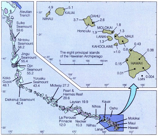
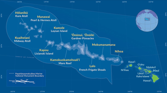
Moving northwest from the Big Island to the other seven islands spread over a distance of 350 miles, we reach the much older Ni’lhau, originally more than 4,500 feet in elevation but now eroded and subsided to less than 1,300 feet. Like the underlying ocean bottom crust, these islands are moving northwest at 3 to 4 inches per year, adding up to an age for Ni’lhau and Laua’l of 5 to 6 million years. Moving farther to the northwest another 1,100 miles, we discover ten minor islands, including Midway and Kure; the whole Hawaiian Archipelago of 18 islands stretches 1,400 miles. But between and beyond these lie numerous atolls and submerged islands known as seamounts, the whole chain adding up to 70 volcanoes created over 50 million years (Figure 5).
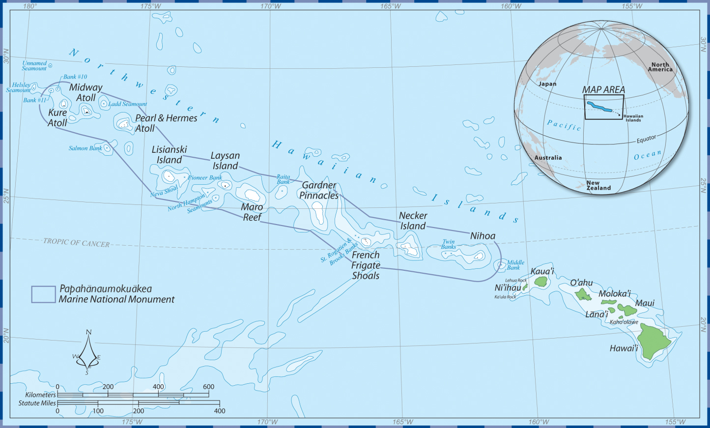 |
| Figure 5. The Hawaiian Islands and Seamounts. The main islands, including the future Lo’ihi, can be seen at the right hand (southeast) end of the chain. As the islands move northwest, they slip below sea level, forming a 1,400-mile line of seamounts. |
The generally decreasing elevation of the islands as they move northwest and their eventual subsidence below sea level is partially caused by erosion, but traces ultimately to the configuration of the Earth’s mantle. Tuzo Wilson, who advanced the theory of hotspots as the origin of the Hawaiian Islands, suggested that a plume rising from the lower mantle is the probable cause. While supplying a continuing flow of lava to crustal vents, massive amounts of magma spread out like a thunderhead under the crust. Explaining the upward bulge of the island chain, Grigg (2014, 26) describes how the mantle plume has “heated, thinned, and uplifted the crust to produce a broad swell three hundred to four hundred miles wide, which itself rises four thousand to five thousand above the bottom of the surrounding Pacific Ocean.” This provides the mechanism for an adjacent ocean depth reduced by as much as 3,000 feet. As the moving seafloor crust, driven by convection in the mantle, approaches the hotspot it rides up this swell. As it traverses the hotspot, it reaches maximum elevation during several hundred thousand years of continuous eruption. The evidence of multiple crevices and vents around Kilauea indicates that thermal plumes rise through branching vents that may vary in the strength of eruption as the crust rides over, blocks some vents, and opens up new channels for lava flow. For two or three million years, each island rides atop this swell until, a few hundred miles to the northwest, it begins its slow slide down the elongated slope of the swell, losing approximately 3,000 feet in elevation. In most cases, this, combined with subsequent erosion of the steep mountainous landscape, results in a disappearance of the island below sea level where it remains as a submerged seamount.
 |
|
| xxx | Figure 6. The Hawaiian Ridge and Emperor Seamounts. Ocean bottom mapping began during the International Geophysical Year (1957-1958). Seafloor cores established dates for the islands and seamounts. Subsequently National Geographic published ocean-floor relief maps of the Indian (October 1967), Atlantic (June 1968), and Pacific (October 1969), combined into a world ocean-floor map (December 1981). The Times Atlas of the World (7th ed. 1985) began labeling undersea ridges and seamount chains on its ocean surface maps. |
At a distance of 2,000 miles from the Big Island, a striking anomaly occurs. The line of submerged seamounts abruptly changes direction. Bending to the north, it heads toward the Russian Kamchatka Peninsula where the seamounts subduct into the 34,400-foot-deep Kuril-Kamchatka continuation of the Aleutian Trench (Figure 6).
The resulting north-south chain adds up to another 40 submerged islands known as the Emperor Seamounts in honor of the Japanese geologist who first identified them. Referring to the “Hawaiian-Emperor Bend” (HEB), Trond H. Torsvik et al (2017) contend that “the HEB cannot be explained without invoking a prominent change in the direction of Pacific plate motion around 47 Ma.” Possible causes within this complicated plate tectonic framework have been explored, but the HEB has remained unexplained; a search for an explanation in adjacent plate movement (Norton 1995) was inconclusive. The Emperor Chain was created over a period of 30 million years; added to the Hawaiian chain, the whole Archipelago chain of 106 volcanoes was created over a period of 70 million years.
This narrative of the Hawaiian Archipelago evolution is particularly rich in detail. Continental movement is most often illustrated with maps depicting the breakup of Pangea, with seafloor spreading as cause, subduction around plate boundaries as effect, and earthquakes as corollaries. However mantle plumes and hot spot geology are still under debate, awaiting fuller investigation of deep-earth heat anomalies at the core-mantle boundary. Meanwhile continuing eruptions of Kilauea reveal how continuous and slow moving lava flows can bury roads and overwhelm entire communities, thus impacting the welfare of humans.
Across the world’s oceans the Hawaiian Archipelago islands and seamounts reveal tectonic movement underlying worldwide geological processes. In his early studies of seafloor spreading, Wilson (1963a) recognized islands as a primary source of evidence; his article on Pacific Ocean hotspot tracks showed several island and seamount chains—notably associated with Pitcairn and Samoa--aligned in the same direction as the Hawaiian Archipelago. These run west, driven by seafloor spreading from the East Pacific Rise, all attesting to underlying hotspots. Several of these tracks show the same bend toward the north that separates the Hawaiian from the Emperor seamounts, thus pointing to the still-unexplained change in Pacific plate movement approximately 40 million years ago.
Numerous island and seamount chains in all major oceans record plate movement across assumed stationary hotspots. The New England Seamounts (Figure 7), a chain of more than twenty extinct volcanoes rising 4,000 meters above the Atlantic seabed, run for 600 miles, recording the westward movement of American plates away from the mid-Atlantic Ridge.
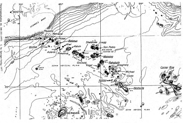 |
| Figure 7. The New England Seamount Chain runs northwest over 600 miles, providing a record of the movement of the North American Plate away from the Mid Atlantic Ridge. Seamount creation originates with the Great Meteor hotspot northeast of Bermuda.
Image: From Baab (2005). |
This chain, the longest in the Atlantic, has been created as the ocean seafloor rides over the Great Meteor Hotspot (Baab 2005). While identified primarily with these seamounts, this hotspot powered volcanic activity in Canada under the Monteregian Hills near Montreal 125 million years ago, and later, under the White Mountains of New Hampshire (Scheirer, 2005). In 2016, President Barack Obama created the Northeast Canyons and Seamounts Marine National Monument (Proclamation 2016), the first U.S. national marine monument in the Atlantic Ocean, which protects the northwest section of the chain. The goal was the protection of an important biodiversity hotspot characterized by various rare and endangered species.
Other prominent examples revealing larger patterns of plate tectonics are found in the South Atlantic and Indian Oceans (Figure 8).
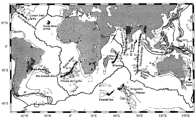 |
| Figure 8. Major hotspot tracks in the Atlantic and Indian Oceans. Shaded dots mark the present locations of hotspots assumed to be fixed in the Earth’s mantle; tracks are dotted at 5-million-year intervals. Tracks in the Atlantic reveal the movement of the earth’s plates away from mid-ocean plate boundaries where mantle lava pushing upward is forcing plates apart. North running tracks in the Indian Ocean and east of Australia record the movement of the Indian plate from Pangea toward Asia 180 to 200 million years ago. Source: Müller et al. Figure 1. Geology (March 1993). |
The primary mechanism occurs at mid-ocean plate boundaries. Summarizing early discoveries, David Olroyd (2006, 100) notes, “It became evident that the ridges tended to have the same form as their adjacent coasts”—the mid-Atlantic Ridge and the facing coastlines providing the clearest illustration. Additionally, “the ridges were found to have narrow ‘rift valleys’ running along their submarine summits,” often marked by black smokers. These were clearly the origination points for upwelling lava forcing plates apart. Thus Mid-Atlantic Ocean provides one of the most extended examples of seafloor spreading from the Arctic Ocean to the South Atlantic. The Rio Grande Rise records westward movement of the South American Plate away from the Mid-Atlantic Ridge. Its mirror image, the Walris Ridge provides evidence not only of the eastward movement of Africa away from the ridge but also an apparent northeasterly movement of the African craton from the more southerly location of Pangea where both continents began their present treks (Müller, Fig. 2).
In the Indian Ocean, north-south alignment of island and seamount chains trace to the northward movement of the Indian plate following the breakup of Pangea (Verzhbitsky 2003).
The Chagos-Laccadive Ridge (Figure 8), which includes the Maldives, runs for 1,600 miles from the present hotspot location at Réunion, with an apparent tectonic discontinuity northeast of Madagascar. Müller’s north-end track extension beyond the Indian Ocean indicates this hotspot may have been the eruptive source of the Deccan Traps of northwest India, sometimes cited as an alternate cause of dinosaur extinction 65 million years ago. The Ninety East Ridge (Stein 1974, Weis 1993), so named because it corresponds almost exactly with the ninetieth meridian (Figure 8), runs north from Broken Ridge for more than 2,000 miles; its age range, older at the north end, indicates a hotspot at the southern end active from 100 to 35 million years ago. East of Australia, the Tasmantid hotspot track records 25 million years of northward movement of the Australian plate.
Seafloor hotspots and seamount chains are often of minor interest: they may rise several thousand feet above the sea floor, but if their summits are hundreds of feet below sea level, their importance is confined to navigation hazards for submarines. Against this largely invisible activity, the current eruption of Kilauea presents a stunning view of island building on a five-vent volcanic assembly already surpassing most in elevation and extent. The flow of lava slowly wending itself to the sea makes clear a process that slowly extends island boundaries and broadens the island foundation as newly deposited chunks of basalt roll down its undersea slopes.
Hotspots on land are of much greater concern, with the discovery of the caldera at Yellowstone the visible evidence that the park straddles a sleeping supervolcano (Figure 9).
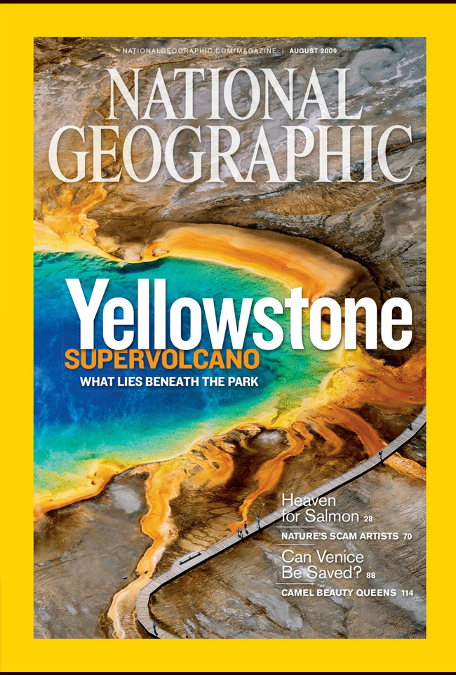 |
| Figure 9. National Geographic Cover, August 2009. Public awareness of the Yellowstone supervolcano dates to the popular press and videos such as the Yellowstone episode in the History Channel series, How the Earth Was Made, First Season (2009). |
In 1903, John Muir introduced the outdoorsman President Teddy Roosevelt to the magnificent landscape of northwestern Wyoming, part natural, part preternatural. Both recognized that it was a landscape unique on the continent, perhaps in the world. Consequently, Roosevelt took steps to preserve it, the first such decision in American history. Yellowstone thus became the flagship national park for a system that has grown to millions of acres. But Yellowstone remains unique and today millions of visitors annually are entertained by what the park offers rather than recognizing it as the most dangerous supervolcano on the planet.
Following half a century of observation, geophysicist Robert B. Smith (1979) published a striking recognition: that surface uplift of 30 inches had occurred at Yellowstone over the half century since he began his research in the park in 1923. The result was recognition that Yellowstone is situated within an ancient caldera atop an enormous hotspot.
Neither Smith nor millions of visitors were aware that this was a scene of a prehistoric eruption because its calderas had been destroyed by erosion long before historical times. Following his recognition, however, Smith and other geologists have undertaken study of crust beneath Yellowstone, revealing a mass chamber of magna. Its signs today are sulphur vents, bubbling pools of water, hot mud flats, and rising clouds of noxious fumes, along with phenomena like the Old Faithful Geyser that seems particularly designed to attract a crowd of spectators awaiting its regular eruptions, which occur approximately every ninety minutes. In addition swarms of deep-origin earthquakes have been a regular occurrence, suggesting that an eruption could break out in the next several thousand years (Achenbach 2009). More recent geological analysis dependent on sophisticated aerial observation and ground-penetrating technology, in combination with plate tectonics (Branny et al. 2008), has revealed that the westward movement of the North American plate across the Yellowstone caldera has generated a line of at least six earlier craters across the Snake River Plain to the Oregon-Nevada border (Figure 10).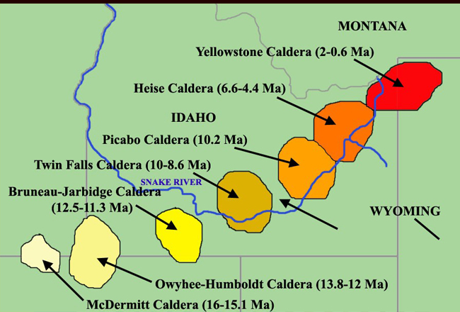 |
| Figure 10. The Snake River Hotspot Track. From Yellowstone National Park in the northwest corner of Wyoming, a southwest movement of the North American plate across a stationary hotspot (now under the Yellowstone Caldera) has generated a line of heavily eroded calderas across the Snake River Plain of Southern Idaho. Dating indicates eruptions from the McDermitt Caldera 16 million years ago on the Oregon-Nevada border to the most recent under the Yellowstone Caldera 600 thousand years ago. Source: Diagram sketched from Branney (2007), Fig. 1. |
This hotspot track provides a geological record of 15 million years of plate movement over the Yellowstone hotspot. Slow-flowing basaltic lava is typical of hotspot eruptions; years of lava flow at Kilauea provide an apt illustration of slow buildup thousands of feet in elevation. Hawaiian in fact is the name for this kind of mild, low-volume, continuous, effusive volcanic type (O’Meara 2008, 40). In contrast, subduction volcanoes along plate margins—typical in the well-known Ring of Fire around the Pacific—tend toward explosive eruptions (Gilbert and Sparks 1998) like the 1981 explosion that blew out half the summit of Mount St. Helens, and the January 2018 eruption of Mount Mayon in the Philippines. Here, water carried down with subducting seafloor, turning to steam at depth, provides an engine for inland volcanoes like the dozens of extinct but potentially dangerous volcanoes that run parallel to the coast in California, Oregon, Washington, and British Columbia. However, despite anxiety on the Big Island fueled by a succession of new crevices and continuous activity over 35 years, Kilauea seems less likely to explode and more likely to continue pushing out miles of slow-moving rivers of lava.
Meanwhile, as this drama continues, a new one is rehearsing in the green room. Twenty miles off the southeast coast of the Big Island, the thermal plume is actively feeding a new seamount, Lo’ihi, which is slowly rising from the flank of Mauna Loa, a predecessor of Kilauea and the largest shield volcano in the world. The evidence suggests that Lo’ihi will be the next Hawaiian island. Its beginning is estimated at 400,000 years ago; it is already 12,320 feet in elevation above the seafloor while its summit remains 3,200 feet below sea level. It covers an elongated seafloor area 8 by 16 miles, the feature behind its name Lo’ihi (“long”); it is growing with 90% of ejected lava sliding down the slopes, progressively enlarging its foundation. At its present rate of growth, it is projected to reach the ocean surface in approximately 50,000 years, by which time the Big Island will have moved another three miles to the northwest. If Lo’ihi continues to add elevation and bulk, it could add a seventh volcano to the Big Island’s six, enlarging its area and shoreline by many miles.
Lo’ihi, which is now the 107th volcano in the 3,600- mile Hawaiian-Emperor Archipelago, was first thought to be an inactive volcano, but seismic activity led to its recognition as an active seamount in 1955. For years it was studied remotely from undersea cameras and samples dredged up from its summit. Two decades from its discovery to the first descent to its peak in 1987 provides an index of difficulties in exploring ocean depths: in the 23-year interval, we put humans into space, made seven landings on the Moon, and lofted 14 Space Shuttles into orbit.
Lava ejected under water cools rapidly, cracking into boulders and irregular rubble known as talus, not unlike steep scree fields around eroding mountains. Oceanographer Richard W. Grigg (2014, 17-19) describes the preternatural scene he discovered on his dive to Lo’ithi. The slopes of are largely built on an unstable foundation, the result being constant slippage detected by seismographs. Earthquakes are frequent, instruments regularly register landslides. Since records began in 1959, between two and ten earthquakes per month have occurred near the summit. In 1996, seismographs registered a swarm of 4,070 earthquakes in a three-week period, a record for any Hawaiian volcano. The result was massive changes: a crater six-tenths of a mile across and 1,000 feet deep formed amidst the rubble, along with the collapse of “Pele’s vents”—named for the Hawaiian goddess of volcanoes—which had formerly been considered stable. The crater has now been renamed “Pele’s Pit.”
Conditions around Lo’ihi’s vents at the summit are toxic. The water temperature averages 196 degrees Fahrenheit (90 Celsius), though its ejection temperature has been measured at 250 Celsius. Oxygen is missing from the seawater; carbon dioxide and iron compounds are high. The seamount is characterized by at least eight hydrothermal vents, both at its summit and down its flanks, around which non-oxidizing microbes thrive (McMurtry, 1987). These resemble microbial communities around black smokers along mid-ocean ridges, now considered a likely location for the first emergence of life nearly 4 billion years ago. Grigg (2014, 19)) suggests that “the summit of Lo’ithi may be the most naturally polluted place in Hawai’i,” adding that “the poisonous zone around the summit of Lo’ithi does not extend to greater depths” where various species of non-vertebrates and fish have been catalogued.
Remarkable and unusual forms of life are typical of the flanks of the Hawaiian islands, including the hundreds of miles of seamounts to the northwest. Richard W. Grigg (1988, 2008) was instrumental in establishing the importance of precious corals in the Hawaiian seamount chain. This has motivated extraordinary efforts to protect the undersea ecology, most recently the creation of a vast sea-bottom marine preserve (Figure 11).
 |
| Figure 11. Papahānaumokuākea. This Marine National Monument, created by President George W. Bush and enlarged by President Barack Obama, extends across the Western end of Ko Hawai’I Pae Āina (The Hawaiian Archipelago). |
As the largest undersea preserve of several around Pacific islands under American control—and in fact in the world—it stretches across 1,350 miles of Hawaiian islands and seamounts, protecting more than 582 thousand square miles of ecologically rich coral and sealife. Created in 2006 by President George W. Bush, it was designated a World Heritage site by UNESCO in 2010 and enlarged by President Barack Obama (Barnett 2016).
A Big History course presentation of Hawaii’s origins provides an incisive introduction to plate tectonics and hotspots and their worldwide occurrence, along with exploration of one of the most environmentally rich regions on Earth. The National Geographic video Wild Hawaii (2014) provides a spectacular survey of both the islands and the undersea world of the seamounts. Recognition of seamount importance is evident in establishment and enlargement of an undersea monument now designated a World Heritage site by the United Nations Educational, Scientific, and Cultural Organization (UNESCO).
In a treatment of “deep time,” oceanographer Richard W. Grigg (2014, 24) points to the imaginative expansion the Hawaii story engenders. “How long will it take Lo’ithi to break the ocean surface and become an island and then drift off the hot spot to the end of the island change and then keep driving to final subduction beneath Kamchatka? The answers are about fifty thousand years, then thirty million years, and finally about seventy million years. How can human minds imagine such immensities?” Grigg’s questions evoke the kind of response James Playfair (1802, xiv) recorded more than two hundred years ago on the view of deep time unfolded by James Hutton: “The mind seemed to grow giddy by looking so far into the abyss of time . . . how much farther reason may sometimes go than imagination can venture to follow.” Grigg refers to the same power of reason: “By projecting one’s mind into the murky past or unknown future of both geological and biological evolution, it is possible to imagine such things.” His perspective provides a philosophical underpinning for the task of Big History: “By mentally going there, we extend our own mortality to a virtual immortality. . . . we must continuously think about the huge amount of time that it took” (Grigg 2014, 24-25). Mention of Pele’s vents and Pele’s pit reminds us of the pervasive mythology of Pele, Hawaii’s Goddess of Fire and Volcanoes who dominates the lore of the islands. Migrant settlers from islands to the south who arrived at the Hawaiian Islands between 1,500 and 1,200 years ago imported a mythology that has evolved within this new environment. In a startling correlation between the real and the imaginary, Pele is said to have settled first Ni’ihau, the oldest of the Hawaiian islands, then migrated southeast to the newest, the Big Island where she now resides. Her migration means she has always been present where volcanic island building was underway. But while Pele is now considered resident around Mount Kilauea, her vents, now collapsed into Pele’s Pit, suggests she may make periodic visits to Lo’ihi.
In my version of Big History—the University of Houston core-curriculum course Cosmic Narratives—I refer to mythic stories as “ancient cosmic narratives,” which defines the changes from prescientific to scientific origin stories as an evolution rather than repudiation. The mythology surrounding Pele is easily discovered in Martha Warren Beckwith’s Hawaiian Mythology (1982) and well-illustrated with paintings, prints, and illustrations by artists: Herb Kawanui Kane (1928-2011), Dietrich Varez (1939-2018), and Wallace Kong.
Herb Kane (1928-2011), educated in the School of Art Institute in Chicago, turned his interest and skill in sailing to the design of a voyaging canoe—undertaking a Kon Tiki-like demonstration of sailing between Tahita and Hawaii, the route of the original Polynesian settlers of the islands. Author of Pele: Goddess of Hawaii’s Volcanoes (1987), an illustrated retelling of the Pele legends, and Voyagers (1993) on the marine background of Hawaii’s settlement, Kane produced dozens of paintings that captured the union of geology and mythic narrative. Seven Kane commissioned paintings, undoubtedly the result of Hawaii’s recent addition (1959) as the newest American state, appeared in the December 1974 issue of National Geographic.
Dietrich Varez (1939-2018), German by birth, settled on the Big Island in an upland forested area where he carved wooden images of Pele, illustrated more than a dozen books, developed a line of handmade jewelry, and produced hundreds of prints (See Figure 2). Living a self-sufficient pioneering life in a home he built near Kilauea, he and his family lived close to the land, collected rainwater, and went without electricity for thirty years, Varez symbolizes an environmental idealism few today follow.Wallace Kong, who continues to work in Honolulu, has focused on the dramatic landscape of Hawaii, its peaceful beaches, craggy mountains, and steeply eroded cliffs. Among these spectacular scenes, Wallace’s painting, “Pele Rejoicing” (Fig. 11) captures the calm of the supreme goddess with a reassuring gesture against a lava-lit sky and towering clouds of eruption.
As a collector of god and goddess statues found in China, Malaysia, Singapore, and Thailand, I was interested in locating a sculpture of Pele to add to my mantle collection. In talking to numerous residents and shopkeepers in Honolulu, I discovered that statues of the goddess did not seem to exist; in fact, I was told that Pele herself would be angered if anyone tried to create such an artifact, though it is evident that some have been carved. What emerged from conversations were personal narratives with a common theme of Pele’s vengeful influence over people who offended her. According to stories heard several times, tourists who had picked up and carried off pieces of Hawaiian lava typically fell victim to bad luck, even personal disaster. Warned by Hawaiian residents that Pele would seek revenge for such looting of her territory, I became the recipient of modern legends that it was not uncommon for former tourists to mail back their volcanic souvenirs in hopes of making peace with Pele and restoring their lives to normal.
In retrospect, I am perhaps better off without Pele on my mantle.
 |
| Figure 12. Pele Rejoicing. A painting by Hawaiian artist Wallace Kong captures Pele as the benign goddess of the Hawaiian land and people, unperturbed by the background of an eruption-lit sky and towering volcanic dust clouds. |
Acknowledgment
* Wherever possible, maps and images are from open access news agencies or government sites. Wallace Kong’s copyrighted image, Pele Rejoicing (Fig. 12), is used by permission. Special thanks are due to geologist-reviewer Olga Garcia-Moreno for a perceptive reading, helpful references, and careful editing. Every attempt has been made to locate the earliest copyrighted sources for illustrations, maps, and other images.
References
Achenbach, Joel. 2009. “When Yellowstone Explodes.” National Geographic 216 (2), August, 56-68.
Alvarez, Walter. 2017. A Most Improbable Journey: A Big History of Our Planet and Ourselves. New York: W. W. Norton.
Babb, Ivar. 2005. “The New England Seamounts”. National Oceanic and Atmospheric Administration. U.S. Department of Commerce.
Barnett, Cynthia (August 26, 2016). “Hawaii Is Now Home to an Ocean Reserve Twice the Size of Texas.” National Geographic. http://news.nationalgeographic.com/2016/08/obama-creates-world-s-largest-park-off-hawaii.html
Beckwith, Martha Warren. 1982. Hawaiian Mythology. Honolulu: University of Hawaii Press.
Branney, M. J., and Graham Douglas Michael Andrews. 2008. “‘Snake River (SR)-type’ Volcanism at the Yellowstone Hotspot Track: Distinctive Products from Unusual, High-temperature Silicic Super-eruptions.” Bulletin of Volcanology 70:3, 293-314.
Brown, Cynthia Stokes. 2007. Big History: From the Big Bang to the Present. New York: The New Press.
Calder, Nigel. 1983. Timescale: An Atlas of the Fourth Dimensions. New York: Viking.
Christian, David. 2004. Maps of Time: An Introduction to Big History. Berkeley: University of California Press.
Christian, David. 2018. Origin Story: A Big History of Everything. New York: Little, Brown and Company.
Christian, David, Cynthia Stokes Bown, Cynthia Stokes, Craig Benjamin. 2014. Big History: Between Nothing and Everything. New York: McGraw Hill.
Cloud, Preston. 1978. Cosmos, Earth, and Man. New Haven: Yale University Press.
Dana, James Dwight. 1891. Characteristics of Volcanoes, With Contributions of Facts and Principles from the Hawaiian Islands. Palala Press. 2018.
Dietz, Robert S. 1961. “Continent and Ocean Basin Evolution by Spreading of the Sea Floor.” Nature 190 (4779): 854–857.
Garcia-Moreno, Olga, et al. 2017. “A Little Big History of Iberian Gold: How Earth processes concentrated the precious metal that played a critical role in the history of Spain and Portugal.” Journal of Big History 1:1 40-58.
Gilbert, J. S. and R. S. J. Sparks. 1998. The Physics of Explosive Volcanic Eruptions. New York: Geological Society.
Grigg, Richard W. 1988. “Paleoceanography of Coral Reefs in the Hawaiian-Emperor Chain.” Science 240, No. 4860, 1737-1743.
Grigg, Richard W. et al. 2008. “Biology of Coral Reefs in the Northwestern Hawaiian Islands.” Coral Reefs of the USA 1. 573-594
Grigg, Richard W. 2014. In the Beginning: Archipelago: The Origin and Discovery of the Hawaiian Islands. Waipahu, Hawaii: Island Heritage.
Hess, Harry H. 1962. “The History of Ocean Basins.” Petrological Studies: A Volume to Honor A. F. Buddington. Princeton: Princeton University Press. 599-620.
History Channel. 2009. Yellowstone [DVD]. How the Earth Was Made [First season]. A & E Television Networks.Kane, Herb Kawainui. 1987. Pele: Goddess of Hawaii’s Volcanoes. Captain Cook, Hawaii: The Kawainui Press.
MacDonald, Gordon A. and Agatin T. Abbott. 1970. Volcanoes in the Sea: The Geology of Hawai’i. Honolulu: University of Hawaii Press.
McMurtry, G. M. et al. 1987. “Chemistry and Microbiology of Loihi Seamount Hydrothermal Vent fields.” EOS, Transactions of the American Geophysical Union 68: 1553.
Morgan, W. Jason. 1968. “Rises, Trenches, Great Faults, and Crustal locks.” Journal of Geophysical Research 73, No. 6, 1959-1982.
Morgan, W. J. 5 March 1971. “Convection Plumes in the Lower Mantle.” Nature. 230 (5288): 42–43.
Morgan, W. Jason. 1972. “Deep Mantle Convection Plumes and Plate Motions.” American Association of Petroleum Geologists Bulletin 56, No. 2: 203-213.
Müller, Dietmar, et al. 1993. “Revised Plate Motions Relative to Hotspots for Combined Atlantic and Indian Ocean Hotspot Tracks.” Geology 16: 275-278.
National Geographic. 2014. Wild Hawaii: Land of Fire and Secrets from the Deep [Video]. Washingto: NGC Networks, LLC.
Norton, I. O. 1995. “Plate motions in the North Pacific: the 43 Ma Nonevent.” Tectonics 14, 1080–1094.
O’Meara. Donna. 2008. Volcano: Spectacular Images of a World on Fire. Buffalo, NY: Firefly Books.
Playfair, John. 1963 [1802]. Illustrations of the Huttonian Theory of the Earth. New York: Dover.
Proclamation 9496. 2016. Northeast Canyons and Seamounts Marine National Monument. U.S. Government: Federal Register. 65159-65167.Scheirer, Dan. 2005. A Hundred-Million Year History of the Corner Rise and New England Seamounts. U.S.: National Oceanic and Atmospheric Administration (NOAA) https://oceanexplorer.noaa.gov/explorations/05stepstones/background/geologic_history/geologic_history.html. Accessed: 19 September 2018.
Smith, R. B. and J. R. Pelton. 1979. “Recent crustal uplift in Yellowstone National Park.” Science 206, 1179-1182.
Spier, Fred. 1996. The Structure of Big History. Amsterdam: Amsterdam University Press.
Stein, S., W. A. Okal. 1974. “Seismicity and Tectonics of the Ninetyeast Ridge Area: Evidence for Internal Deformation of the Indian Plate.” Journal of Geophysical Research 83 (B5): 2233.
Swimme, Brian, and Thomas Berry. 1992. The Universe Story: From the Primordial Flaring Forth to the Ecozoic Era—A Celebration of the Unfolding of the Cosmos. San Francisco: Harper.
Torsvik, Trond H., et al. 2017. “Pacific plate motion change caused the Hawaiian-Emperor Bend.” Nature Communications 8, (June). Article number: 15660
Varez, Dietrich, and Pua Kanaka’ole Kanahele. 1991. Pele: The Fire Goddess. Honolulu: Bioshop Museum Press.
Verzhbitsky, E. V. 2003. “Geothermal Regime and Genesis of the Ninety-East and Chagos-Laccadive Ridges.” Journal of Geodynamics, Vol. 35, Issue 3, 289-302.
Wegener, Alfred. 1915. The Origin of Continents and Oceans. New York: Dover, 2011.
Weis, D. et al. 1993. “The Influence of Mantle Plumes in Generation of Indian Oceanic Crust.” Geophysical Monograph. 70:57-89.
Wilson, John Tuzo, 1963a. “Evidence from Islands on the Spreading of Seafloors.” Nature 197 (4837), 536-538.
Wilson, John Tuzo. 1963b. “A Possible Origin of the Hawaiian Islands.” Canadian Journal of Physics 41 (6): 863–870.